Bokabil Fm
Type Locality and Naming
Higher formation of Surma Gr. The type section is in Hailakandi Valley, northern Cachar, Assam, India. [Original Publication: Evans, P. (1932) Tertiary succession in Assam, Trans. Min. Geol. Insti, India, Vol. 27, pp: 173-200.]. Reference section: Silchar-Halflong road and the Patharia Well-1
Synonyms: Boka Bil. Evans proposed it as Bokabil stage within Surma Series. Biswas (1961) considered it as a basic rock unit of formation rank. Chakraborty et al (1974) designated it as a subgroup and introduced Angartoli Fm as equivalent of the Bokabil, in the Garo and western Khasi Hills. The upper Bokabil in Mikir Hills was designated as Khoraghat Sandstone Member (Deshpande et al., 1993).
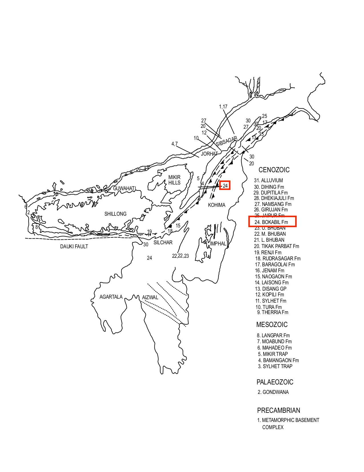
[Figure 1: Geological set up and formation stratotypes of North East Basins (modified after Pandey and Dave, 1998)]
Lithology and Thickness
Sandy claystone. In Assam, the Bokabil Formation is represented by 900 to 1,500 m of sandy shale alternating with siltstone and ferruginous sandstone. Grey laminated and flaky shale, with soft grey sandstone towards top in the Schuppen Belt. In Mizoram, it consists of grey to pale grey, sandy shale with few beds of medium- to coarse-grained ferruginous sandstone. In Dhansiri Valley, the dominant lithology is shale with subordinate sandstone in the lower parts.
In the Bangladesh hill ranges of greater Sylhet and Chittagong district, it is mainly composed of alternating bluish-grey to yellowish-grey, well-bedded siltstone and shale with subordinate light yellowish-brown to brown, fine- to medium-grained, bedded to massive, hard sandstone, locally calcareous and conglomeratic. There, generally shale and siltstone dominate the lower and the upper parts while in the middle part the sandstone percentage is much higher. It occupies a transitional zone between the underlying dominantly sandy Bhuban Fm and overlying Tipam Sandstone Fm (now renamed as Jaipur Fm).
The thickness of the Bokabil in Tripura area is 1133 m in Rokhia-1, whereas in adjoining Mizoram it is around 950 m (Deshpande et al., 1993). Maximum thickness in the South Shillong Plateau is 1130 m. In Schuppen Belt its maximum thickness reduces to 400 m. In Mikir Hills, the thickness of Bokabil Fm is widely variable and reaches up to 970 m in Bar Harihajan-Narjan area (Roy and Mukherjee, 1976).
Relationships and Distribution
Lower contact
The Bokabil Fm gradationally overlies Upper Bhuban Fm in most part of the basins. In the Garo Hills, MIkir and Dhansiri valley, it unconformably overlies the Barail Gr sediments.
Upper contact
Its upper contact is conformable and gradational with the Jaipur Fm (= former Tipam Sandstone Fm, the lowest formation of Tipam Gr). There is a local unconformity between its upper Bokabil Fm and the lower Tipam Gr in Sylhet in northeastern Bangladesh.
Regional extent
Khasi & Jaintia Hills, Mikir Hills, Dhansiri Valley, Naga Schuppen Belt, Tripura Cachar, SE Bangladesh: Bokabil Fm is traceable from western extremity of Garo Hils along southern margin of Shillong. It is exposed in Barail, Tripura-Cachar-Mizoram area, Schuppen belt and Mikir Hills. In subsurface it is encountered in wells drilled in Dhansiri Valley, Cachar and Tripura.
GeoJSON
Fossils
Baruah et al., (1996) reported Globorotalia obesa, G. cf. acostaensis, Globigerinoides trilobus and Streptochilus globigerum from the upper part of Bokabil Formation at Patharia-A in Cachar area in Assam.
Age
Depositional setting
Additional Information
The Boka Bil Formation contains natural gas in economic quantities in Bangladesh.
